
An Inter-District and Inter-Department Coordination During Flood Triggered By Intense Rainfall
The heavy rains of October 3 and 4 unleashed flood-like conditions across North Bihar and its neighbouring regions, laying bare the vulnerabilities and the resilience of a landscape marked by a complex hydrology. The Burhi Gandak catchment, with its headwaters in Nepal and western Champaran districts of India, bore the brunt of an unusually intense spell that persisted for two days. What followed was not merely a struggle against rising waters, but a vivid demonstration of coordinative action across districts, departments, and the community—an orchestration aimed at preventing a catastrophe that could have swollen the ranks of the displaced and the damaged.
 Context and Baseline Conditions
For three consecutive years before this monsoon, the region had experienced rainfall lower than the long-term average. Wetlands, ponds, tanks, and oxbow lakes—lifelines for irrigation and domestic use—had already been stressed by water scarcity. The arrival of an extreme rainfall event in the Burhi Gandak basin, however, reversed the scarcity narrative and created an abrupt hydrological pressure on embankments, protective barriers, and settlement margins. The river, nourished by multiple sub-catchments, drew in inflows from Nepal and the Indian side’s western Champaran districts, with elevations playing a role in how the flood wave propagated downstream. Upstream gradients at higher elevations funneled more water toward lower-lying pockets in Sugauli, Banjaria, and Motihari in East Champaran, as well as in Majhaulia, Paschim Champaran (West Champaran).
Inter-District Dynamics: The Geography of Impact

Paschim Champaran (West Champaran): Among the affected areas, Majhaulia block registered relatively lesser impact, owing to its geography and perhaps the early influence of containment measures. Yet, its proximity to the East Champaran border meant it remained in a high-alert zone, as water levels swelled from upstream surges.
East Champaran: The border blocks—Sugauli, Harsidhi, Banjaria, and Motihari—saw more pronounced inundation. In particular, a breach near Gudara, close to the Paschim Champaran border, intensified flooding across Majhaulia and extended into adjacent tracts in Sugauli.
Sugauli and Banjaria: These blocks experienced multiple embankment breaches, leading to widespread inundation that affected agricultural lands, settlements, and livelihoods across substantial swathes of the landscape. The breaches amplified the flood’s reach, trapping water in broader areas and elevating risk to crops and homes.
Motihari: The downstream effects from upstream breaches manifested in localised inundations, illustrating how upstream hydrological events can casually affect districts farther along the river continuum.
Area of Impact and Human Dimensions

Approximately 670 square kilometers of agricultural land and inhabited areas faced inundation, with crops damaged and livelihoods threatened. The flood’s footprint extended across farming belts, villages, and settlements, impacting tens of thousands of residents who depend on the river and its adjunct waters for irrigation, drinking water, and daily life. The scale demanded rapid, well-coordinated responses across agencies and administrative levels.
Inter-Departmental Coordination: The Machinery Behind the Response
The narrative of mitigation is inseparable from the story of coordination—between district administrations, water resources departments, and community actors. The response unfolded through a sequence of synchronized actions:
Immediate Containment and Stabilisation:
District administrations in both West and East Champaran activated rapid response protocols. In Majhaulia, where the boundary breach had the potential to propagate floodwaters into adjacent East Champaran zones, repair teams commenced on-the-spot stabilization within the same day. The objective was to arrest further escalation and to create a buffer against cross-border propagation.

In East Champaran, emphasis was placed on quick stabilisation of breached embankments in Sugauli and Banjaria to curb the spread of floodwaters into downstream zones, including parts of Motihari.
Embankment Repairs and Protective Infrastructure:
Restoration of breached barriers and priority reinforcement of vulnerable embankments became a focal point. The inter-district push aimed at preventing re-breaching and ensuring that embankments could withstand the pressure of rising waters from multiple upstream sub-catchments.
The repair work was not isolated to one district; instead, it reflected a concerted cross-district approach to preserve the integrity of the entire river corridor.
Resource Mobilization and Material Support:
The Water Resources Departments of both Paschim Champaran and East Champaran coordinated the procurement and provisioning of essential materials such as polybags, nets, and other protective gear. The goal was to fortify embankments and bolster the resilience of vulnerable stretches against future surges.
Materials, logistics, and technical know-how were shared across district lines to ensure uniformity in protective measures and to prevent gaps in coverage.
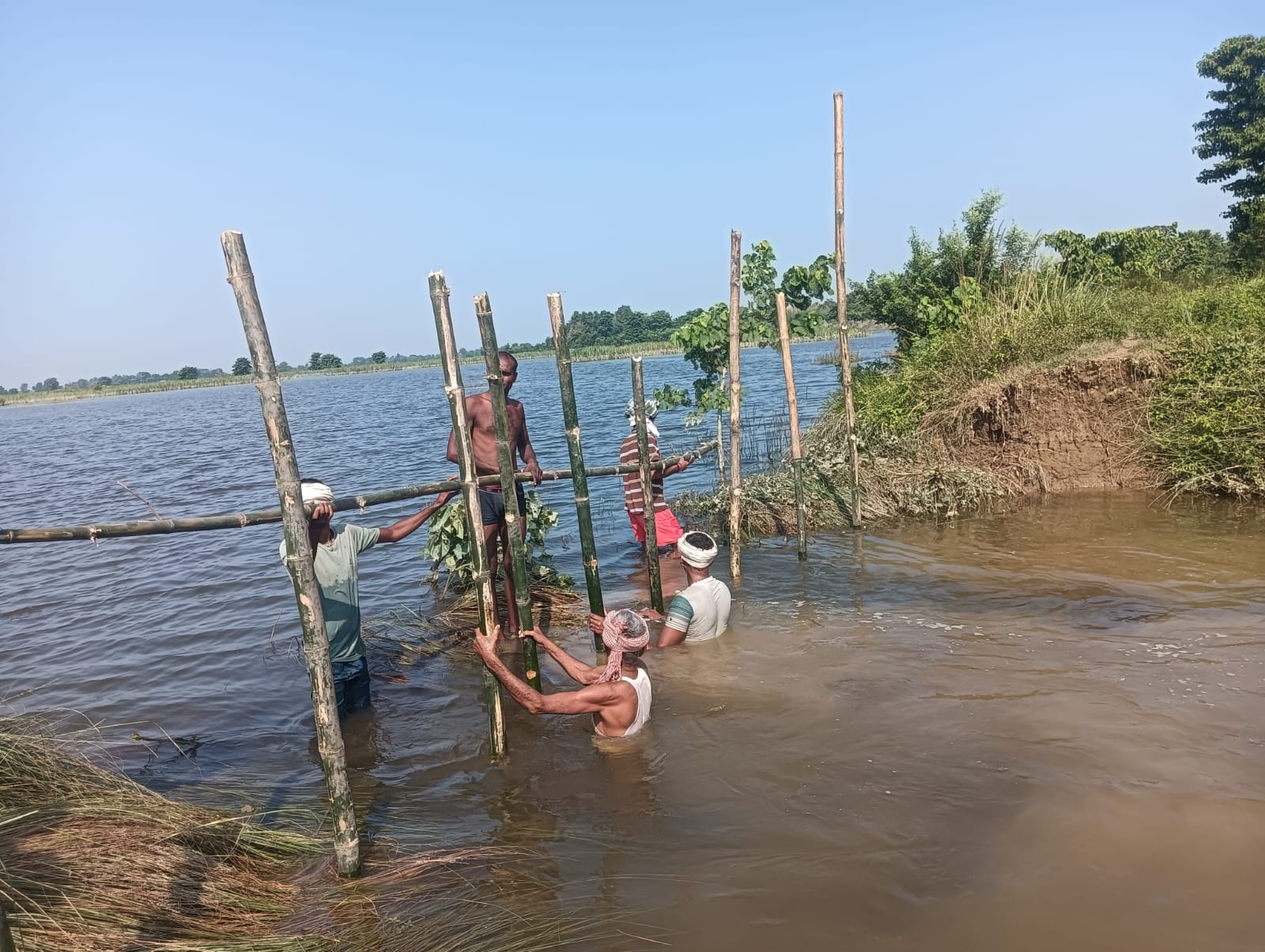
Community Engagement and Labour Mobilisation:
Local communities, aided by district administrations, actively participated in repair drives. The Mahatma Gandhi National Rural Employment Guarantee Act (MGNREGA) mechanism was invoked to marshal labour for timely embankment maintenance. This approach leveraged local labour, provided livelihoods, and ensured rapid on-ground execution of containment strategies.
Public awareness efforts, warnings, and engagement with farmers and households were critical to reduce exposure and to safeguard critical agricultural assets.
Inter-Departmental Synergy:

The coordination encompassed not only district-level agencies but also cross-departmental collaboration within the state machinery—ranging from flood control, irrigation, disaster management, and rural development to police and civil administration for security and compliance.
Real-time data exchange, joint field assessments, and unified command posts facilitated cohesive decision-making. The aim was to translate the upstream hydrological data into actionable, locally tailored interventions.
Outcomes and Lessons
Averted Scale of Devastation: The swift, cross-district repairs and preventive measures limited widespread devastation. The rapid stabilization of embankments prevented a larger flood footprint across Majhaulia and extended relief to Sugauli and Banjaria.
Cross-Border and Cross-Administrative Imperatives: The event highlighted the transboundary nature of riverine disasters, where upstream events in Nepal and adjacent Indian districts influence downstream districts. A unified approach—bridging borders—proved essential to manage a shared hydrological risk.
Community-Centric Resilience: Engaging local communities through MGNREGA proved effective in mobilising manpower, expediting repairs, and fostering a sense of collective responsibility for flood risk mitigation.
Looking Ahead: Strengthening the Cadence of Cooperation
Institutional Frameworks for Inter-Departmental Action: Formalize joint protocols for inter-district and inter-department coordination during flood events, including standardized communication channels, shared incident command structures, and pre-approved resource pools.
Community Resilience and Livelihoods: Expand community-based adaptation programs, ensure risk-informed farming practices, diversify livelihoods, and promote water storage and conservation strategies that reduce vulnerability during extreme rainfall episodes.
In sum, the October rainfall event in the Burhi Gandak basin demonstrated that the strength of disaster response rests not merely in technical fixes but in the social and administrative architecture that binds districts and departments into a unified force. When inter-district cooperation, inter-departmental coordination, and community participation align with timely action, even formidable hydrological shocks can be mitigated, protecting lives, crops, and the livelihoods that hinge on these waters.
- A Manrega-Powered Saokpit Initiative Transforming Local Water Management in Madhubanighat, Motihari
- A State-wide Campaign of Public Sports Grounds: Lifeblood of Community Recreation in Bihar

